


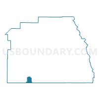
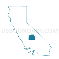
Voting District 21615, Tulare County, California
About
Outline

Summary
| Unique Area Identifier | 545514 |
| Name | Voting District 21615 |
| County | Tulare County |
| State | California |
| Area (square miles) | 24.00 |
| Land Area (square miles) | 24.00 |
| Water Area (square miles) | 0.00 |
| % of Land Area | 100.00 |
| % of Water Area | 0.00 |
| Latitude of the Internal Point | 35.82938990 |
| Longtitude of the Internal Point | -119.14482230 |
Maps

Graphs
Select a template below for downloading or customizing gragh for Voting District 21615, Tulare County, California


Neighbors
Neighoring Voting District (by Name) Neighboring Voting District on the Map
- Voting District 10810, Kern County, CA
- Voting District 10815, Kern County, CA
- Voting District 10820, Kern County, CA
- Voting District 21505, Tulare County, CA
- Voting District 21540, Tulare County, CA
- Voting District 21820, Tulare County, CA
- Voting District 21995, Tulare County, CA
- Voting District 54385, Tulare County, CA
- Voting District 54480, Tulare County, CA
Top 10 Neighboring County Subdivision (by Population) Neighboring County Subdivision on the Map
Top 10 Neighboring Place (by Population) Neighboring Place on the Map
Top 10 Neighboring Elementary School District (by Population) Neighboring Elementary School District on the Map
- Delano Union Elementary School District, CA (54,938)
- Earlimart Elementary School District, CA (10,604)
- Richgrove Elementary School District, CA (3,249)
- Ducor Union Elementary School District, CA (1,276)
- Columbine Elementary School District, CA (262)
Top 10 Neighboring Secondary School District (by Population) Neighboring Secondary School District on the Map
- Delano Joint Union High School District, CA (70,221)
- Porterville Unified (9-12) School District, CA (47,072)